
Read [pdf] or back to [Publikasi kami]


Read [pdf] or back to [Publikasi kami]
Read PDF or back to Publikasi kami.

Read PDF or Publikasi kami.

Read PDF or Publikasi kami.

Oil and gas fields reservoired by basement rocks show that the composing rocks are never single, but consist of many types of rock (sedimentary, metasedimentary, metamorphic, intrusive and extrusive igneous rocks). Variations in production in different parts of the field will be determined by how fracturing occurs in the basement rocks. In addition, for field development, it is important to know how these basement rocks accrete to each other. Unfortunately, to know the character of these basement rocks and their accretion cannot be known significantly from the exploration carried out because it would require many exploration wells that penetrate the basement rocks. Even detailed seismic survey is not enough to do.
However, a field analogue approach can be taken, namely by looking at the accretion of basement rocks that have been uplifted to the surface, at the outcrops of basement rocks. Such an analogue field is provided by Belitung Island, Indonesia. Belitung Island is entirely composed of various types of Pre-Tertiary basement rocks and the geological mapping that has been carried out by geologists has revealed knowledge about how these basement rocks were accreted. Therefore the basement rocks accretion model on Belitung Island can be a field analogue for subsurface basement rocks which are targets for exploration and production in Sumatra, Java or Southeast Asia regionally.
Apart from that tectonically, the basement rocks of Belitung Island also prove the theory of terrane tectonics. Basement rocks on this island are rocks related to the drifting of the Indochina Terrane, opening of the Paleo-Tethys Ocean, closing of the Paleo-Tethys through subduction and collision from Sibumasu Terrane, and magmatism it caused. Most of the events related to terrane tectonics are recorded in the Pre-Tertiary tectono-stratigraphy and magmatism of Belitung Island.
This paper will first discuss the geology of Belitung Island, the interpretation of its terrane tectonics, then the application of the accretion pattern of its basement rocks for the purposes of exploration and production of petroleum in basement rocks.
This paper was presented at the Indonesian Petroleum Association Annual Convention and Exhibition 2024.
[pdf]

Paper yang ditulis oleh Mas Virga (BMKG) beserta kawan-kawan dari ITB, BRIN, GFZ, dan UGM ini mengulas mengenai detil struktur kegempaan yang terjadi 18 tahun yang lalu di Yogyakarta. Gempa bumi yang terjadi pada tanggal 26 Mei 2006 dengan magnitud Mw ∼6,4 ini merupakan salah satu gempa bumi paling merusak di Indonesia. Gempa tersebut menimbulkan ribuan korban jiwa, puluhan ribu luka-luka, dan ratusan ribu kerusakan rumah di wilayah Yogyakarta dan sekitarnya dengan kerugian yang besar. Studi sebelumnya dari tomografi seismik dan pencitraan radar satelit berhipotesis bahwa gempa tersebut disebabkan oleh aktifnya sesar yang sejauh ini tidak diketahui di sebelah timur Sesar Opak. Padahal, sesar Opak awalnya diduga menjadi sumber terjadinya gempa tersebut. Dugaan tersebut muncul karena kerusakan terparah terjadi di wilayah Bantul sebelah barat Sesar Opak. Studi ini menunjukkan bahwa tomografi seismik kami mempunyai resolusi yang lebih tinggi dibandingkan penelitian sebelumnya dan dapat menggambarkan sistem sesar yang terjadi. Kami memanfaatkan lebih banyak gempa susulan dan ukuran grid yang lebih kecil untuk inversi tomografi seismik. Kami berhasil menggambarkan Sesar Opak dan sesar kedua yaitu Sesar Ngalang pada kedalaman 9 km. Dua sesar ini ditunjukkan oleh kontras kecepatan Vp, rasio Vp/Vs, dan Vs dari tomogram bagian horizontal. Kedua sesar tersebut dihubungkan oleh Sesar Oyo yang patahnya berlawanan arah dibandingkan kedua sesar tersebut. Semoga bermanfaat. Salam.
Baca artikel ini di penerbit.

Ini merupakan judul sebuah buku yang diluncurkan dalam acara pelepasan purnabakti Pak Hery Harjono sebagai peneliti di Pusat Penelitian Geoteknologi LIPI. Buku ini berbentuk bunga rampai, yaitu kumpulan dari beberapa artikel yang membahas tektonik sepanjang Busur Sunda yang ditinjau dari sudut geologi dan kegempaannya. Penulis-penulis yang berkontribusi di dalamnya adalah kolega-kolega Pak Hery Harjono semasa aktif di LIPI. Selain itu Prof. Subagyo Pramumijoyo (Geologi UGM) yang merupakan sahabat beliau juga memberikan untaian kata pengantar di awal buku ini. Salam.
Buku ini dapat diunduh di sini atau dari situs penerbit.
Maulin dan kawan-kawan 2021, Buletin Geologi
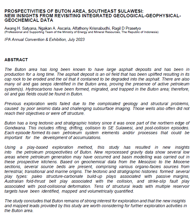
Subcekungan Tarakan sangat menarik namun kurang dieksplorasi. Di sebelah utara, subcekungan ini dibatasi oleh Sesar Sampoerna dan di selatan dibatasi oleh Sesar Mangkalihat. Kedua patahan regional tersebut merupakan patahan geser mengiri yang menghasilkan pengaturan unik terhadap proses sedimentasi delta dan proses deformasi yang terjadi di daerah tersebut.
Struktur geologi yang berkembang di Subcekungan Tarakan berorientasi relatif timurlaut-baratdaya dengan jenis sesar normal di bagian ekstensi atau proximal secara pengendapan delta dan sesar anjak (toe-thrust) di bagian kontraksi atau distal. Kesejajaran pola antara sesar normal dan sesar anjak dalam suatu area yang sama kerapkali menimbulkan kesalahtafsiran bagi para explorationist yang bekerja di area ini. Analisis struktur geologi berupa analisis deskriptif, kinematik dan dinamik dilakukan untuk mengetahui proses deformasi pada area ekstensi dengan mempertimbangkan proses sedimentasi Delta Tarakan. Pengukuran laju sedimentasi terhadap besaran throw dari masing-masing sesar normal dilakukan untuk mendapatkan Expansion Index (EI) sebagai gambaran terjadinya sesar tumbuh. Selanjutnya evaluasi terhadap sesar tumbuh dilakukan dengan restorasi penampang untuk mengetahui proses deformasi yang terjadi berupa strain dan adanya kemungkinan lain selain pergerakan normal yang diisi sedimen delta.
Deformasi yang terjadi di area penelitian dapat dikenali sebagai tektonik delta yaitu proses sedimentasi yang menghasilkan kontrol gravitasi terhadap deformasi batuan. Berdasarkan analisis yang dilakukan, sesar-sesar normal yang berada di area ekstensi merupakan sesar tumbuh dengan indeks pertumbuhan (EI) yang bervariasi terhadap umur batuan dan lokasi sesarnya. Hasil analisis terhadap beberapa sesar tumbuh menunjukkan indeks pertumbuhan sesar bervariasi terhadap throw dan laju sedimentasi pada downthrown-nya. Indeks pertumbuhan yang tidak sempurna diamati pada sesar-sesar yang terletak di bagian barat area penelitian, diduga terpengaruh aktifitas pengangkatan struktur pada Pliosen sehingga mengerosi sebagian besar sedimen sesar tumbuh. Adanya pergerakan aktif Sesar Sampoerna dan Sesar Maratua memberi pengaruh terhadap konfigurasi tektonik delta (gravity inducetectonic) berupa inversi sesar tumbuh yang sekaligus membentuk closure bagi pemerangkapan hidrokarbon.
Baca artikel lengkapnya di sini.
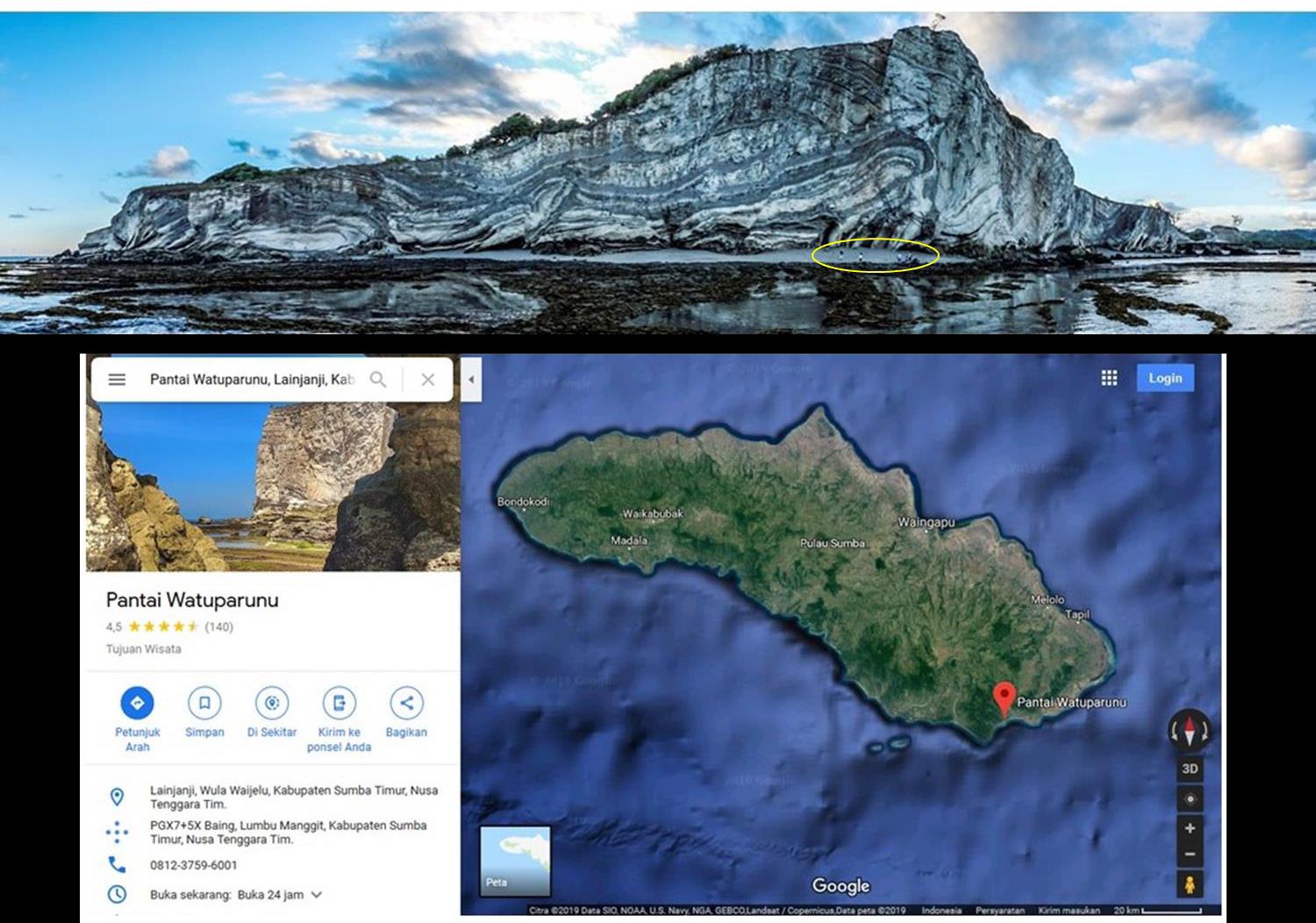
Mass transport complex in east Sumba: a reference from world-class outcrop at Watuparunu coast – Mio-Pliocene gravity slumps
Proceedings, Indonesian Petroleum Association Forty-Third Annual Convention & Exhibition, September 2019
Awang Harun Satyana, Aries B. Nugroho, Cipi Armandita, Ferry Yustiana
Abstract
Watuparunu Coast in Southeast Sumba Island, Indonesia is composed of coastal cliff demonstrating excellent – world-class outcrop of deep-water mass transport complex (MTC) with complicated deformation related to gravity slumps. Seismic data (2D and particularly 3D) have recently enabled large MTC’s of Recent to ancient deep-water basin to be described in considerable detail. However, the exposures of MTC’s are scarce therefore, outcrop reference to examine seismic interpretation are seldom available. MTC outcrop of Watuparunu Coast recently accessible, could provide the reference. MTC is subaqueous mass flow or landslide deposits that move downslope due to gravity sliding. It is important to study MTC’s since these mass movement processes represent significant threats to the security of continental slope and deep-marine engineered installations, including deep-water exploration and development; geo-hazards for tsunamis to coastal communities; release of methane to atmosphere from frozen gas hydrates originally stored in slope areas but released upon MTC; the roles of MTC in deep-water petroleum system. MTC’s characterized the geology of East Sumba in Mio-Pliocene time. Within the period, East Sumba subsided to the north and east as response to the uplift of the Masu Mountains to the south and opening of the Savu Basin to the east. This caused gravity sliding from high to low areas. Volcano-clastic rocks eroded from the Masu Mountains and pelagic marls and chalks of Kananggar Formation were deposited and moved downslope forming slides, slumps, or debris flow and they continued into the Savu Basin. Around 1 km long and 20-50 m high of the coastal cliff outcrop show the MTC at Watuparunu Coast. Slump structures dominate the MTC, forming very tight fold and thrust system. The top of the MTC is irregular erosional surface, its bottom is not exposed but it is considered as planar detachment surface where all faults ramp to. Internal facies consisting of: rotated blocks, pressured ridges, folded and thrusted blocks, and chaotic facies. This is the first publication and study of Watuparunu outcrop complex as MTC. This excellent outcrop provide reference to study slump structures of MTC’s which globally comprise up to 70% of the entire slope and deep-water stratigraphy. Exploring and developing petroleum in deep-water area should aware these deposits for the sake of engineering aspects and petroleum system. MTC’s may act as both lateral and top seals for underlying hydrocarbon reservoirs and could create MTC-related stratigraphic traps.
Read full text here
Giant fields of Indonesia: play types, geologic factors, and prospectivities of future giant fields
Proceedings, Indonesian Petroleum Association Forty-Third Annual Convention & Exhibition, September 2019
Awang Harun Satyana

Abstract
Seventeen oil and gas fields of Indonesia are classified as giant fields (estimated ultimate recovery/ EUR/ reserve ≥ 500 MMBO or 3 TCFG) and two as supergiant fields (EUR ≥ 5000 MMBO or 30 TCFG) with total reserves 3P (proven+probable+possible) of 38.17 BBOE. The fields are located in eleven sedimentary basins with the Central Sumatra Basin being the richest basin volumetrically. The supergiant fields: Minas oil field (reserve 3P 5.45 BBO) and Natuna D-Alpha gas field (contingent recoverable resource 3P 46.30 TCF, undeveloped) are the largest oil and gas fields in Southeast Asia.
Globally, the number of giant fields is only 2% of the total fields of all sizes, but they contribute 60% of the production (Merrill and Sternbach –AAPG, 2017) and account for 67 % of the world’s petroleum reserves (Mann et al., 2003). The situation is similar in Indonesia, where most of the oil and gas production has come from 16 producing giant fields. Most of these are very mature, and are presently in production decline. Therefore, the discovery of giant fields is very important for the national petroleum production and reserve. To explore systematically the prospectivities of future giant fields of Indonesia, the play types, geologic factors, and tectonic settings of the existing giant fields are evaluated. The nineteen giantsupergiant fields of Indonesia can be simply grouped into six play types with each reserve 3P as follows:
The evaluation provides lessons for exploring the possibility of future giant fields in Indonesia: play type/s that can still account for new giant fields or new play type/s that should be developed. The play types of future giant fields, their locations and petroleum systems are determined by geologic settings, and some areas to focus on are proposed in this study.
Read full text here
