Peta Sumber dan Bahaya Gempa Indonesia Tahun 2024

Disusun Oleh:
Pusat Studi Gempa Nasional (PuSGeN)
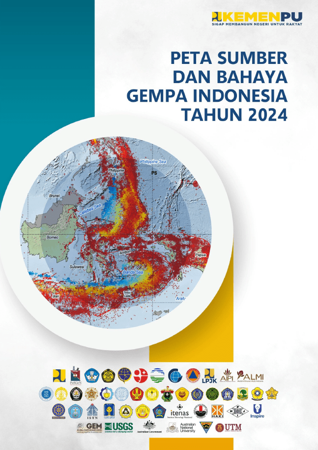
EXECUTIVE SUMMARY

Peta Sumber dan Bahaya Gempa Indonesia (Peta Gempa Indonesia) merupakan acuan nasional yang sangat penting dalam penetapan beban gempa untuk kebutuhan perencanaan pembangunan yang aman terhadap gempa. Sejak peluncuran Peta Gempa Indonesia 2017, telah terjadi sejumlah gempa besar seperti Gempa Lombok (2018), Palu (2018), Halmahera (2019), Ambon (2019), Mamuju (2021), Pasaman Barat (2022), dan Cianjur (2022). Gempa-gempa tersebut menimbulkan korban jiwa, kerusakan infrastruktur, serta menyebabkan kerugian ekonomi yang mencapai triliunan rupiah untuk rehabilitasi dan rekonstruksi.

Oleh karena itu, diperlukan upaya mitigasi untuk mengurangi dampak kerusakan akibat gempa, salah satunya melalui perencanaan dan konstruksi yang baik, yang sejak awal telah mempertimbangkan risiko gempa dalam desainnya. Salah satu informasi paling krusial yang dibutuhkan dalam perencanaan struktur dan infrastruktur tahan gempa adalah Peta Gempa Indonesia, yang menjadi acuan dalam penataan ruang, perancangan struktur bangunan, serta penyusunan regulasi teknis untuk bangunan gedung dan infrastruktur lainnya.

Peta Sumber dan Bahaya Gempa Indonesia 2024 (Peta Gempa Indonesia 2024) merupakan pembaharuan terhadap Peta Sumber dan Bahaya Gempa Indonesia 2017 (Peta Gempa Indonesia 2017). Dalam hal ini pemutakhiran yang dilakukan mencakup dalam penentuan jalur dan geometri sesar, penentuan segmentasi sesar, penambahan sumber gempa (sesar aktif), pengkajian skenario rupture, perhitungan magnitudo potensial (Mmaks), dan penentuan laju gerak (slip rate) sebagai masukan/input dalam membuat model bahaya gempa bumi yang lebih akurat. Selain itu dalam pemutakhiran peta gempa ini telah digunakan rumus atenuasi atau GMPE terbaru yang sesuai dengan kondisi kegempaan di Indonesia.

Peta Gempa Indonesia 2024 yang disusun untuk memperkuat ketahanan nasional terhadap risiko gempa bumi dan memastikan pembangunan infrastruktur yang lebih aman serta sesuai dengan kondisi geologi terkini. Pembaruan utama dalam peta ini meliputi:

  • Penambahan sumber gempa baru, baik di darat maupun laut, berdasarkan identifikasi sesar aktif yang lebih rinci. Jumlah sumber gempa dalam model meningkat signifikan dibanding versi sebelumnya. Pembahasan rinci mengenai sumber gempa dan karakteristik sesar aktif disajikan dalam Bab II.
  • Pembaharuan peta katalog kompilasi gempa Indonesia hingga tahun 2024 (Katalog PuSGeN 2024), termasuk gempa-gempa besar seperti Cianjur 2022 dan Bawean 2024 yang belum tercakup dalam Peta Gempa Indonesia 2017. Katalog ini telah direlokasi menggunakan model kecepatan 3D untuk meningkatkan akurasi posisi hiposenter, yang penting untuk estimasi laju kejadian gempa. Penjelasan teknisnya dibahas dalam Bab III.
  • Peningkatan akurasi data pemodelan, melalui integrasi data geologi, geodetik (GPS), dan seismologi terbaru. Hal ini mendukung pemodelan laju gempa dan propagasi getaran tanah yang lebih andal, sebagaimana dijelaskan dalam Bab IV hingga Bab VI.
  • Pemilihan GMPE (Ground Motion Prediction Equation) yang lebih sesuai dengan kondisi tektonik Indonesia, berdasarkan hasil studi dan evaluasi terbaru. Rincian metodologi dan hasil evaluasi GMPE dibahas dalam Bab VII.

PuSGeN melalui pokja-pokja telah melakukan berbagai pengembangan terkait penambahan sensor pengamatan gempa, data, metodologi, dan pengetahuan terkini dalam memetakan dan menganalisis karakterisasi segmen sesar aktif di Indonesia. Pada Peta Gempa Indonesia 2024 ini, telah dipetakan 401 sumber gempa beserta parameternya. Terdapat penambahan 129 sumber gempa baru, sedangkan jumlah segmentasi Megathrust pada peta tahun 2024 menjadi 14 segmen, dengan penyesuaian kedalaman slab hingga 40 km-50 km (Hayes et al., 2018), serta penyesuaian pada segmentasi Jawa, Halmahera, Sulawesi Utara dan Filipina. Sebagai contoh segmen Halmahera dan segmen Papua disesuaikan mekanismenya menjadi thrust.

Di wilayah Jawa, jumlah segmen sesar aktif meningkat dari 36 pada tahun 2017 menjadi 82 pada tahun 2024. Jumlah segmen di Sumatra meningkat dari 56 segmen pada 2017 menjadi 86 segmen pada 2024. Wilayah Nusa Tenggara-Banda bertambah 21 segmen baru menjadi 68 segmen. Wilayah Maluku-Papua, yang dikenal memiliki aktivitas tektonik yang tinggi, mengalami penurunan jumlah segmen dari 80 pada 2017 menjadi 78 pada 2024. Sementara itu, Kalimantan mencatat kenaikan dari 3 segmen pada 2017 menjadi 10 segmen pada 2024.

Sejalan dengan pembaruan pada model sumber gempa, proses pemodelan guncangan tanah (ground motion modeling) juga mengalami perubahan yang signifikan. Sebagaimana dibahas dalam Bab VII, model prediksi guncangan tanah (Ground Motion Prediction Equations/GMPEs) yang baru dipilih melalui proses evaluasi terstruktur yang melibatkan para ahli dari dalam dan luar negeri).

Untuk sumber kerak dangkal, GMPE yang digunakan pada pemodelan tahun 2024 relatif serupa dengan yang digunakan pada tahun 2017, yaitu yang diadopsi dari proyek NGA-West2. Model-model tersebut mencakup GMPE oleh Boore et al. (2014), Campbell dan Bozorgnia (2014), serta Chiou dan Youngs (2014), yang telah terbukti memberikan prediksi yang andal untuk gempa bermagnitudo menengah hingga besar di wilayah tektonik aktif. Untuk gempa subduksi, baik megathrust (interface) maupun Benioff (intraslab), dipilih GMPE dari Abrahamson dan Gülerce (2020), Kuehn et al. (2020), serta Zhao et al. (2006), yang dinilai mampu merepresentasikan perilaku guncangan tanah yang kompleks pada kedua jenis gempa tersebut.

Dalam penyusunan Peta Gempa Indonesia 2024, pendekatan logic tree diterapkan secara eksplisit untuk mengakomodasi berbagai bentuk ketidakpastian ilmiah pada beberapa komponen utama. Logic tree digunakan untuk memberikan bobot pada dua jenis model frekuensi kejadian gempa, yaitu Gutenberg–Richter dan model karakteristik, yang menggambarkan distribusi gempa besar dan kecil di suatu sumber. Selain itu, logic tree juga diterapkan pada parameter seismisitas (termasuk slip rate), pemilihan beberapa fungsi atenuasi (GMPE) yang dianggap relevan dengan kondisi geologi Indonesia, serta pada penetapan magnitudo maksimum (Mmaks). Melalui logic tree, seluruh variasi model ini dimasukkan ke dalam perhitungan bahaya gempa secara sistematis, dengan pembobotan yang proporsional untuk menghasilkan estimasi yang lebih representatif dan transparan.

Penyusunan peta ini dilakukan dengan menggunakan pendekatan Probabilistic Seismic Hazard Analysis (PSHA) untuk menghasilkan estimasi bahaya gempa yang komprehensif. Proses ini dijelaskan secara lengkap dalam Bab VIII.
Hasil akhir dari penyusunan Peta Gempa Indonesia 2024 adalah kumpulan peta kontur yang menggambarkan percepatan tanah di batuan dasar (Site Class B) untuk berbagai periode ulang. Peta ini disajikan dalam bentuk percepatan puncak (PGA) serta percepatan spektral pada periode getar 0,2 dan 1,0 detik, untuk berbagai tingkat probabilitas terlampaui dan masa layan. Terdapat sembilan belas (19) jenis Peta Gempa Indonesia Tahun 2024 mencakup periode ulang mulai dari 50 tahun hingga 10.000 tahun.

Berdasarkan hasil kajian Tim Pemutakhiran Peta Gempa Indonesia 2024, disampaikan rekomendasi agar pemutakhiran peta gempa Indonesia dilakukan secara berkala atau berkelanjutan dan sistematis. Siklus pembaruan ini penting mengingat terus berkembangnya informasi ilmiah seperti identifikasi sesar aktif baru, data deformasi permukaan dari pengukuran geodesi, hasil relokasi episenter dan tomografi, pemutakhiran fungsi atenuasi (GMPE), serta kemajuan dalam perangkat lunak dan metode komputasi analisis bahaya gempa.

Wilayah dengan potensi gempa bermagnitudo ≥6, terutama yang berdekatan dengan kota-kota besar, direkomendasikan untuk menjadi prioritas riset lanjutan yang lebih detail, komprehensif, dan terintegrasi. Sebagai bagian dari upaya peningkatan ketangguhan wilayah dan infrastruktur nasional terhadap bahaya gempa, pemutakhiran Peta Gempa Indonesia 2024 tidak hanya bersifat teknis, tetapi juga harus diiringi dengan dorongan terhadap riset kebencanaan yang mendalam, termasuk pemetaan mikrozonasi dan potensi dampak ikutan seperti likuefaksi, gerakan tanah, dan tsunami.

Download [PDF]

Hybrid turbidite–contourite systems in the modern Tarakan Basin: seismic sedimentology and analogue for subsurface storage (Nugraha & Maulin, 2025)

Hybrid turbidite–contourite systems are present where gravity-driven and bottom-current processes interact. Although recent studies have advanced our understanding, deciphering the relative roles of downslope and alongslope processes in shaping the deep seafloor remains an important subject of investigation. The Tarakan Basin, offshore northeastern Borneo, is a prolific hydrocarbon province, yet its modern sedimentary systems are poorly understood. Shaped by rapid deltaic sedimentation, active tectonics, and ocean currents–the South China Sea Throughflow (SCSTF) and Indonesian Throughflow (ITF) – the basin offers an ideal setting to study hybrid deepwater processes. Here, we conducted seismic sedimentology analysis to quantify morphometric parameters, delineate seismic facies, and interpret depositional processes using 3D seismic reflection data. Three segments are identified. The Northern Segment is dominated by upslope-migrating sediment waves and plastered drifts, indicative of contourite-dominated conditions. The Central Segment hosts a canyon–drift complex, formed by synchronous interaction of turbidity flows and bottom currents. In contrast, the Southern Segment is shaped mainly by turbidity currents, with gullies and associated sediment waves suggesting limited bottom current influence. These spatial variations reflect a spectrum of hybrid depositional styles, consistent with global models of contourite-, synchronous-, and turbidite-dominated systems. The sedimentary patterns observed provide an analogue for subsurface reservoir and seal distribution, relevant to both petroleum and carbon storage systems.

Citation: Nugraha HD and Maulin HB (2025) Hybrid turbidite–contourite systems in the modern Tarakan Basin: seismic sedimentology and analogue for subsurface storageFront. Earth Sci. 13:1614416. doi: 10.3389/feart.2025.1614416

Seismic velocity structure beneath the western Java region, Indonesia, from local earthquake tomography

Journal of Volcanology and Geothermal Research https://doi.org/10.1016/j.jvolgeores.2025.108472

The western Java region is situated along the Sunda Arc, which is formed by subduction of the Indo-Australian Plate beneath the Eurasian Plate. The subduction process causes seismic activity in the Wadati-Benioff zone of the descending slab, produces a chain of active volcanoes, and forms numerous faults in the terrestrial and back-arc region of the overriding plate. This study examines the region’s tectonic system via seismic tomography, in which the most recent earthquake catalog from the Indonesian Agency for Meteorology, Climatology, and Geophysics (BMKG) is utilized. Body wave travel time from 4561 local-regional earthquakes recorded by 78 seismic stations produces a 3-D Vp and Vp/Vs ratio model. The subducting Indo-Australian Plate slab is characterized mainly by high Vp and low Vp/Vs anomalies and exhibits steeper subduction than the Slab2 model. Partial melting zones, which serve as magma sources for several volcanoes, are observed at depths of about 90–100 km, characterized by low Vp and high Vp/Vs anomalies. The Lembang and Cimandiri fault lineaments are visible at 10 km depth and are characterized by negative Vp and positive Vp/Vs anomalies. This study also successfully demonstrates that the source of the damaging 2022 Cianjur earthquake occurred in a region dominated by low Vp and high Vp/Vs. These anomalies most likely relate to fluids or molten material in the fault zone. This study again highlights the importance of the BMKG seismic network for understanding tectonic systems on a local-regional scale, in this case, through the lens of seismic tomography.

Authors: W. Wandono, M. Ramdhan, A.N. Aulia, A.B.Pangestu, E. Hidayat, S. Syuhada, S. Widiyantoro, Nicholas Rawlinson, T.Anggono, B. Pranata, M.M. Mukti, M.P. Maulana

Present-day inter-seismic velocities and fault slip rate of Ketahun segment, Sumatran Fault System (SFS) inferred from Global Positioning System (GPS) observations

Ashar Muda Lubis, Rida Samdara, Rio Sahputra, Lina Handayani, Qiu Qiang, Agnis Triahadini, Muhammad Maruf Mukti, Oktadi Prayoga

Tectonophysics, Volume 914, 25 November 2025, 230879, https://doi.org/10.1016/j.tecto.2025.230879

Highlights

  • We modelled GPS data during 2018–2024 to estimate the slip rate and locking depth of Ketahun segment.
  • We find the importance of viscoelastic response and megathrust coupling effect in our analysis.
  • The Ketahun segment slip rate is 14.5 [−1.2, +1.3] mm/yr and locking depth of 14.4 [−4.9, +4.8] km.
  • The Ketahun segment is capable of generating a magnitude ∼6 to 7+ in the future.

Abstract

The Ketahun segment of the Sumatran Fault System (SFS) is distinctive and tectonically active segment, yet the slip rate of the segment is not widely known. The Ketahun segment underwent two major earthquakes of Ms 7.6 in 1946 and Ms 6.8 in 1952, respectively. Using Global Positioning System (GPS) data, we aim to better estimate the slip rates using a dislocation elastic model following a Bayesian approach with Metropolis Markov chain Monte Carlo (MCMC) samplers to estimate optimum fault parameters. Then we determined the potential amount of cumulative energy stored at the segment. We processed raw GPS data from 35 GPS stations, combining from GIA, SuGAr, and UNIB networks during 2018–2024 using GAMIT/GLOBK software. The daily GPS solutions were constrained into the ITRF-2014 frame, and the GPS velocities were translated into Sunda block. Before we model the trench parallel GPS velocities, we attempted to correct the viscoelastic velocities due to the 2007 Mw 8.4 Bengkulu earthquake incorporating the effect of megathrust coupling on the trench parallel GPS velocities. We find the importance of viscoelastic response and megathrust coupling effect in our analysis, providing better slip rate and locking depth estimation. Our result inferred that the estimated fault slip rate is 14.5 [−1.2, +1.3] mm/yr with a locking depth of 14.4 [−4.9, +4.8] km across in the Ketahun segment. The segment is capable of generating a magnitude ∼6 to 7+ if a single earthquake occurs every 50 to 200 years.

Read article at publisher

Update daftar publikasi

Ini adalah update publikasi kami sampai pertengahan tahun ini. Semoga bermanfaat. Salam.


Godang, S., Saputro, S. P., Li, H., Satyana, A. H., & Srichan, W., 2025. Geochemistry of the Adang volcanics in Western Sulawesi: Unveiling the tectonic evolution of the opening of the makassar strait. Solid Earth Sciences, 10(1), 100228. https://doi.org/10.1016/j.sesci.2025.100228 (open access) [link] [pdf]

Handayani, L., Mukti, M. M., Arisbaya, I., Gaol, K. L., Sudrajat, Y., Lubis, A. M., & Anggono, T., 2025. Basement structure across Renun segment near Toba caldera inferred from the gravity anomaly: Implication for potential earthquake rupture barrier. Geodesy and Geodynamics. https://doi.org/10.1016/j.geog.2025.04.006 (open access) [link] [pdf]

Ramdhan, M., Palgunadi, K. H., Mukti, M. M., Librian, V., Daniarsyad, G., Muttaqy, F., … & Febriani, F., 2025. Aftershock sequence of the Yogyakarta earthquake 2006 (Mw~ 6.4), Indonesia, based on analysis of hypocenter relocation, static, and dynamic stress. Natural Hazards, 1-21, https://doi.org/10.1007/s11069-025-07440-8 [link] [pdf]

Ramdhan, M., Priyobudi, P., Mukti, M. M., Putra, A. S., Hidayat, E., Muttaqy, F., Syuhada S.,
Hanif, M., Widiyantoro, S., Librian, V., Susilawati, A., Madrinovella, I., & Wandono, W., 2025. Tracing fault systems from subsurface to surface in Yogyakarta and its surroundings, Indonesia. Natural Hazards Research, https://doi.org/10.1016/j.nhres.2025.07.003 (open access) [link] [pdf]

Satyana, A.H., (2025). Natural hydrogen systems in various geotectonic settings of Indonesia: Bottom–up approach. Indonesian Petroleum Association Forty-Ninth Annual Convention & Exhibition [link] [pdf]

Satyana, A.H., 2025. Paleogene to Neogene Volcanisms of Eastern Margin of
Sundaland: Petrotectonic Evolution and its Implications to Petroleum Exploration in the Makassar Strait, South Arm of Sulawesi, and Bone Basin. Indonesian Petroleum Association Forty-Ninth Annual Convention & Exhibition [link] [pdf]

Syuhada, S., Muttaqy, F., Anggono, T., Pranata, B., Puspito, N.T., Ramdhan, M., Febriani, F., Mukti, M.M., Dewi, C.N., Hasib, M. and Prasetio, A.D., 2025. Spatial variation of crustal anisotropy in Simeulue Island, Indonesia, from shear wave splitting analysis. Physics of the Earth and Planetary Interiors, p.107362. https://doi.org/10.1016/j.pepi.2025.107362 [link] [pdf]


Untuk melihat semuanya, klik di sini.

Riset Geologi dan Pertambangan Volume 35 No 1 (2025)

Cover Page

Dear RGP readers,


We are delighted to deliver the first issue of Volume 35 of Riset Geologi dan Pertambangan (Geology and Mining Research). This issue publishes five papers dealing with seismic hazards, tectonic geomorphology, and granite mineralogy. Hermawan et al. present their work on distribution of PGA values on bedrock in central Java area using Probabilistic Seismic Hazard Analysis. They further suggest that there is a necessity in earthquake mitigation to minimize losses when a major earthquake occurs in the future. The second article by Fahrezi et al. describes seismic hazard
evaluation using seismic response analysis in Bengkulu area. In the third article, Maryudhaningrum et al. elucidate the role of groundwater extraction and natural consolidation to land subsidence in Bandung Basin.

The fourth article by Faturrakhman et al. presents a new insight into hydrogen exploration by using tectonic geomorphology to identify key target areas based on their tectonic activity in relation to the occurrence of active faults in central Sulawesi area. Whereas, the last paper by Elly et al. is dealing with new petrography and X-ray diffraction data of granite from Hukurila area that contributes in understanding granite petrogenesis in Ambon, eastern Indonesia.

We acknowledge the authors and reviewers for their valuable works and contributions to this issue. Many thanks to the editorial members and staffs for their continuous support for the publication of this first issue of this year. We welcome your scientific contributions for the next upcoming issues.

Sincerely,
The Editors of RGP

Riset Geologi dan Pertambangan is now indexed in Scopus

We are excited to share that our journal, Riset Geologi dan Pertambangan is now indexed in Scopus and ranked by the SCImago Journal & Country Rank (SJR)

Riset Geologi dan Pertambangan (Geology and Mining Research) is a gold open-access journal managed voluntarily by Earth science enthusiasts, supported, and published by BRIN Publishing (ISSN 0125-9849, e-ISSN 2354 6638). We believe that Earth science research should be inclusively accessible for everyone. There is no fee to submit manuscripts and no cost to read our peer-reviewed articles.

Our journal publishes research papers, reviews, and short communications in geosciences-related interdisciplinary topics. We are pleased to invite researchers and practitioners in these fields to contribute to the journal by sharing their research, insights, and perspectives. 

Riset Geologi dan Pertambangan Volume 34 No 2 (2024)

Dear RGP readers,

We present the second issue of Volume 34 of Riset Geologi dan Pertambangan (Geology and Mining Research). This second issue publishes five papers dealing with engineering geology, geological resources, sedimentary geology, and hydrogeology. In the first article, Dzaki et al. present landslide susceptibility zone using the weight of evidence method in the south of Yogyakarta. Their landslide susceptibility map shows that the research location is predominantly characterized by areas with medium to high susceptibility to landslides. Furthermore, the medium and high susceptibility zones are situated close to the rivers that related to the alignment of faults.

Kamal et al. discuss modelling a two-dimensional map of soil parameters in Bengkulu based on research points strategically distributed throughout the city. The parameters include shear wave velocity, cone resistance, and corrected standard penetration test. The research points represent the diverse soil conditions in the area, making the modelled soil parameters useful for planning construction.

The third article by Solihin et al. briefly reviews different aspects of nickel ore, such as its history, types, distribution, demand, and the technology used for mining and processing it. Indonesia has significant nickel ore deposits, primarily in the form of laterite, due to its tropical climate with high temperatures and rainfall. The authors also discuss advanced materials made from laterite ore, including photocatalysts and batteries.

In the fourth article, Anhaer et al. clarify sedimentary facies and sedimentation mechanism of volcaniclastics of Cikarang Member of Jampang Formation in southern part of Bogor Trough. They measured stratigraphy of the rock units supported by petrographic analysis and paleontological analysis. The rock units consist of 11 lithofacies deposited in inner-middle fan with changes in depositional sub-environment variations of channels, sandy lobes, silty-sandy distal lobes, and proximal levees. The volcaniclastics are deposited by turbulent current with various cohesive debris flows.

The last paper by Nugraha et al. evaluates the performance of the Krylov Subspace method with adaptive preconditioning compared to classical iterative methods, such as Gauss-Seidel, Jacobi, and Successive Over-Relaxation (SOR), in the simulation of steady-state groundwater flow on a 2D grid. They conclude that the Krylov Subspace method with adaptive preconditioning is the best solution for applications that require high efficiency in groundwater flow computing.

We sincerely acknowledge all the authors and reviewers for their valuable contributions to this issue. We recognize all the editorial members and staffs for their continuous fineness support for the publication of this volume. Happy new year and we wish all of you a successful continuation in scientific work and
achieving interesting results of scientific research in the coming year, all the best!

The Editors of RGP


Read this volume here or at publisher.

The origin of Baribis Fault and its relationship to the dynamics of Sunda Arc

Based on analyses of published geological cross sections along the Baribis Fault, we briefly review several possible mechanisms of this backarc thrust that developed behind the volcanic arc in western Java. There is no general agreement regarding the mechanisms of the backarc thrust. Therefore, the origin of this fault remains uncertain. Previous works proposed that the backarc thrust in western Java may have developed as deformation of paleo-accretionary wedge sediments behind a continental backstop, inverted normal fault, northward migrating thrust belt, and thrusting due to gravitational sliding of the volcanic arc. However, evidences supporting those mechanisms still need to be elucidated. Detailed examination of the available geological data might suggest that backarc thrusting in western Java may have formed due to stress transfer through rigid arc blocks. The far-field stress from the subduction zone is propagated through remnants and modern volcanic arcs and finally, deformed sediments in the Bogor Trough that nucleated as backarc thrust.

Authors:

Hanief Ajib Abdalla, Nasywa Dhia Khalifa, Cyntia Adrian Lestari, M. Maruf Mukti, Akhmad K Gibran, Fadlin


Read pdf here or at publisher

Riset Geologi dan Pertambangan Volume 34 No 1 (2024)

Dear RGP readers,


We present the first issue of Volume 34 of Riset Geologi dan Pertambangan (Geology and Mining Research). This issue publishes five articles that covered topics on hydrogeology, mining, petrology, and geochemistry. In the first article, Mareta et al. present the water critically index of Welaran area in Central Java, Indonesia. The higher the WCI value, the more concerned the water conditions in the area will be. The water crisis can be handled if various parties manage water resources following good management. The Welaran area is part of the Lukulo Watershed, where the population often experiences water shortages. In 2020, Karangsambung has been designated as a part of Kebumen Global Geopark, which will certainly increase the number of tourists visiting here. The increase in tourist visits will also increase the need for water, including in the Welaran Watershed. The second article by Kasih et al. briefly explained mine drainage system design in a coal mine in Kalimantan, Indonesia. This mine drainage system aims to ensure that mining activity areas are not flooded during the rainy season. The drainage system consists of designing sump dimensions, open
channels, settling ponds, and pumping and piping systems. In the third paper, Al Kausar et al. elucidate geochemical analysis, including major, trace and rare earth
elements, conducted by fusion ICP-MS to find out the different composition of volcanic rocks in the Karaha-Talagabodas fields in West Java, Indonesia. The major element diagram shows the sampled rocks consist of calc-alkaline for andesite of Karaha and basalt, basaltic andesite, and andesite of tholeiitic environments for the Talagabodas volcanic rocks. The normalized REE diagram of N-MORB shows the similarity of the pattern of all Talagabodas volcanic rocks, whereas the Karaha andesite rocks show
slight REE enrichment and europium depletion. The next article investigates the possibility of using flotation process wastes from Buzlukdağı feldspar beneficiation plant, Türkiye as an alternative raw material. Ozgul & Ozcelik evaluate the use of wastes from feldspar enrichment and feldspar processes as alternative raw materials in another process and investigating their usability as a final product in various sectors and fields. The results show that the process can be used for technological purposes. Furthermore, the wastes from the enrichment can be used to provide permeability in urban waste storage areas and hydroelectric dam construction.
In the last paper, based on analyses of published geological data, Abdalla et al. reviewed several possible mechanisms of this backarc thrust in western Java. Previous works proposed that the backarc thrust in western Java may have developed as deformation of paleo-accretionary wedge sediments behind a continental backstop, inverted normal fault, northward migrating thrust belt, and thrusting due to
gravitational sliding of the volcanic arc. However, evidences supporting those mechanisms still need to be elucidated.


Riset Geologi dan Pertambangan – Geology and Mining Research welcomes your contributions in the forthcoming issues. We sincerely acknowledge all the authors and outstanding reviewers for their valuable contributions to this issue. We recognize all the editorial members and staffs for their continuous fineness support for the publication of this volume.
The Editors